Chartered Geodetic Engineer Vladimir Ivičević – Dubrovnik.
My Office provides land survey services in Dubrovnik area and geomatics solutions generally and holds “Authorization for Conducting Land Survey” released by the State Geodetic Administration of Croatia.
Main Activities:
- Development studies and applications for Land Cadastre and Real Estate Cadastre
- Line Cadastre
- Land Survey Design Layouts
- Land survey study
- Situational blueprints
- construction staking
- Shift monitoring / analysis
Area of Activity: City of Dubrovnik, Konavle Municipality, Municipality Zupa of Dubrovnik, Dubrovnik Primorje (Coast Area) Municipality, Municipality of Ston, Near Islands including Mljet , Peljesac (Municipalities Janjina, Trpanj & Orebic)
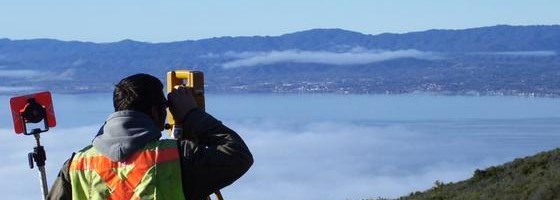
For all surveys we deploy hi-tech terrestrial and satellite surveying equipment, operated by qualified surveyor.
Available services:
- Survey services for investment preparation and design for :
-
- hotels with facilities
- sport centers, leisure centers, parks, large sculptures
- coastal villas, urban villas, houses
- airports, border crossings, ports, harbors
- highways, roads, railways, walking trails
- schools, universities, libraries, concert halls and other public buildings
- pipe lines, cable lines
- real-estate, mining and engineering purposes
- Survey services for construction (same kind of objects as above)
- Services subject to official registration related to municipalities and national cadastral offices within Croatia.
- Building and construction survey services on land and offshore
- Research and engineering survey services
- Officially recognized surveys within Croatia
- Installation and survey control point network for construction sites
- Identification and setting out of official boundaries of real-estate
- Pilot plans and site map of construction fields
- Division and combining parcels including registration within Croatia
- Archaeological surveys and mapping services
- Urban and city planning services
- Tree and horticultural surveys
- Architectural surveys
- Setting the Standards for Sport Objects and Tracks
- Surveying and mapping for mining, geophysics, and geology engineering
- Deformation, consolidation and settlement surveys
- Submarine surveys
Contacts in English :
- Cellphone : +385 98 243 598
- Email : geodet@geo-ivicevic.hr